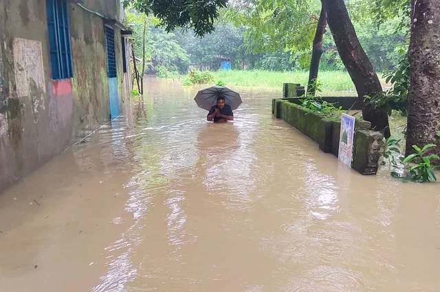
There was no forecast of the heavy rainfall and severe flooding across the Chittagong and Sylhet divisions. On August 18, the country’s Flood Forecasting and Warning Centre had only mentioned the rise in water levels of rivers. The Indian Flood Forecasting and Warning Centre also did not provide any such information. As a result, the sudden severe flooding has left the eastern part of Bangladesh in distress.
If there is a threat of a major and sudden flood coming from India, it is customary for it to be specially communicated by the Joint Rivers Commission of the two countries. In the past three days, record-breaking rainfall has occurred upstream in the Indian river Bilonia on the Muhuri River. The water level rose rapidly, but no special warning was given to Bangladesh by India’s Central Water Resources Ministry.
The executive engineer of the country’s Flood Forecasting and Warning Centre, Sarkar Uday Raihan, told Prothom Alo about the situation: “We receive information about the rise in water levels from the Indian parts of the Gomati and Matamuhuri rivers from their website. They also officially provide information twice a day; however, this time we were not given detailed information. Without detailed information, it becomes difficult to provide accurate and comprehensive flood forecasts.”
When there is heavy rainfall in the upstream areas of India’s Teesta, Brahmaputra, and Ganges basins, the water takes three to seven days to flow downstream to Bangladesh, causing monsoon floods. However, heavy rainfall in Tripura reaches Feni, Noakhali, and Chittagong in five to eight hours. In such urgent situations, India should have quickly informed Bangladesh. There should be an agreement between the two countries, mandating information exchange in such cases.
According to data from the Flood Forecasting and Warning Centre, there was extremely heavy rainfall in the eastern part of the country from August 19 for three consecutive days, the highest in 53 years. The sudden heavy rainfall, combined with the surge of water from upstream and the narrowing paths for the water to drain, has rapidly worsened the flood situation.
According to the Meteorological Department, such heavy rainfall is not typical in the eastern region in August. Typically, continuous rainfall at the end of the month affects mainly the coastal and central areas of the country. In August, Feni and Comilla have also experienced very heavy rainfall before, but it did not last more than a day or two. There has been intermittent heavy rainfall in the Chittagong and Noakhali regions over the last month. In the last week of the previous month, most districts in the region recorded rainfall between 100 and 200 millimeters. In the second week of the current month, heavy rainfall continued.
The Meteorological Department reported that 304 millimeters of rain fell in Parshuram, Feni, on August 20, the highest in 53 years. This year in Comilla, 188 millimeters of rain fell in 24 hours, the highest since 1968, when there was once 442 millimeters of rain in 24 hours. Upstream in India’s Bilonia River in southern Tripura, 146 millimeters of rain fell in 24 hours this year. This record-breaking rainfall upstream and downstream has rapidly worsened the flood situation in Bangladesh.
Experts say that one of the five responsibilities of the Joint Rivers Commission is to provide accurate flood forecasts. If water and flood information for the 54 shared rivers between India and Bangladesh were exchanged properly and flood forecasts were presented comprehensibly, such a major disaster could have been avoided.
Narrowed Pathways for Water Drainage
The floodwater drains through rivers like Gomati, Feni, Khowai, and Matamuhuri in Bangladesh, most of which have been silted and encroached upon over the past two decades. According to the National River Protection Commission, there are 11,447 encroachers in areas like Comilla, Feni, and Noakhali alone. If we consider the entire Chittagong division, this number rises to around 20,000. River, canal, and wetland encroachment is causing problems with water drainage during floods.
The River Protection Commission published a list of encroachers across the country in December 2022. A large portion of them were leaders, activists, and influential members of the then-ruling party. Among the flood-affected areas, there are approximately 6,000 encroachers in Comilla, 277 in Feni, 4,303 in Noakhali, and 1,041 in Lakshmipur.
Mohammad Ejaz, Chairman of the River and Delta Research Centre (RDRC), told Prothom Alo, “Just as we need accurate information from India about the surge of water coming from upstream, we must also keep the pathways for that surge clear after it arrives. The Joint Rivers Commission and the River Protection Commission could have played the most significant roles in this. These two institutions have been made ineffective. It is time to strengthen and make these institutions effective.”
River and water expert Ainun Nishat told Prothom Alo, “Bangladesh’s flood and weather forecasting systems need to be overhauled. The type of forecasts we currently provide do not allow us to predict severe disasters like the ongoing floods in advance. From India, we receive detailed information about the water flow in the Ganges and Teesta. However, we do not get the same level of detail for other rivers like the Gomati and Muhuri.”
BRAC University’s Emeritus Professor Ainun Nishat further stated that one of the reasons for this flood is said to be the opening of the gates of the Dumbur Dam in Tripura, India. However, the reality is that when water levels rise, the sluice gates of the Gomati Hydroelectric Power Station open automatically. Once the water level decreases, they automatically close again.


